Showing posts with label Natural Nipomo. Show all posts

Friday, August 22, 2008

Natural Nipomo: Hidden Willow Valley

Tucked away deep in the Guadalupe-Nipomo Dunes, in the places people rarely visit, are some of the most spectacular places to visit. Densely vegetated dunes and open sand sheets give way to a veritable dune oasis.

Welcome to Hidden Willow Valley, part of the Guadalupe-Nipomo Dunes National Wildlife Refuge. Carved low into the sand by the same aeolian forces that drive the movement of the dunes, this is a place where nature and culture intertwine.

The place is known for willow trees, but the greater diversity of life is stifling. It is an ecotone, a place where different plant communities meet and provide unique habitat for animal life.

This truly is a wild place. The moisture draws many birds, deer and other animal life. Mountain lions—one of several hazards present in the dunes (keep an eye out for poison oak and ticks too)—roam the dunes and frequent places like Hidden Willow Valley, where they are more likely to find prey.

The Dunites, a group of people who sought beauty and seclusion in the dunes, spent years living in low-lying areas similar to Hidden Willow Valley where water was easily accessible. They spread word of the dunes far and wide, and left a legacy of dune-inspired poetry.

Kathleen Goddard Jones, a woman who spent years fighting to keep a nuclear power plant from being built in the dunes, spent the latter years of her life exploring the dunes with her husband Gaylord Jones and giving names to places like Hidden Willow Valley.

Walking along the marked trail that goes through Hidden Willow Valley, I came across a spur that led to a small glade. Within the glade, next to an inviting log-bench, is an aging mailbox. I sat there awhile, absorbing the energy of the place and examining the contents of the mailbox—a logbook where visitors tell their stories, a book of Dunite poems, and personal items left by previous travelers.

Here I read Dunite poetry from a book left in the "hidden" mailbox by Norm Hammond, a well known dune historian.

I urge you to leave your own note in the logbook, but remember these words. In an essay from the book Imagine What American Could Be in the 21st Century, given to me by a friend, Fred Branfman writes, “We can feel truly alive and at peace in the present only if we know that we are contributing to the future.”

There are of course many ways to contribute to the future. One of the easiest ways is to simply be aware of the physical impact you can have on a place as sensitive as Hidden Willow Valley. A large careless group can cause as much damage as an off-road vehicle.

It’s critical to obey the laws established to protect natural places—in this case, no camping, no fires, no dogs—and to respect the rights of neighboring property owners and nesting plovers. To do any less would be to rob the future of yet another irreplaceable place.

Contact the Dunes Center in Guadalupe for information about upcoming hikes to Hidden Willow Valley and other parts of the National Wildlife Refuge.

Thursday, August 21, 2008

Natural Nipomo: The Chumash

Critical to understanding the nature of a place is an understanding of the nature of the people who live there. In the case of Nipomo, the most successful inhabitants are the native Chumash. Over the course of more than 9,000 years they maintained a sophisticated culture rich in craftsmanship, legend, and natural knowledge.

Prior to the mission period the Chumash had a wide range, stretching along the coast from San Carpoforo Creek near Ragged Point in the north to Malibu in the south, and laterally from the coast to the western extremes of the Central Valley.

Chumash people lived in villages in places where resources were abundant, including the Nipomo region. Despite a lack of centralized leadership, trade regularly took place between villages. Disputes were usually settled nonviolently, but occasionally ritualized skirmishes would take place.

The Chumash are known for the use of wood-plank canoes, known as tomols. These vessels facilitated the exchange of goods and people between the northern Channel Islands and the densely populated Santa Barbara coastline.

Utilizing a much larger vessel, Juan Rodriquez Cabrillo was the first European to make contact with the Chumash as he surveyed the west coast of New Spain in 1542. Later explorers, including Sebastian Vizcáino in 1602 and Juan Gaspar de Portolá in 1769, had various encounters with the Chumash while also naming many coastal features.

Juanipero Serra came to San Luis Obispo in 1772 to found the first mission in Chumash lands. Four more would be built over the course of the next 36 years, irreversibly altering the native way of life. New villages formed around the missions, and the Chumash were taught crafts that helped support the mission economy.

The California missions were disbanded in 1833, shortly after Mexico gained its independence.
Land formerly held by the missions was broken up and granted to private landowners, leaving little for the Chumash to return to. Some managed to go back to their old way of life, but most went to work on the ranchos as vaqueros and servants.

Much of what we know of the Chumash today is thanks to the efforts of anthropologist John Harrington and the natives he spoke with, who themselves spent much of their lives acquiring knowledge of their culture. His papers are the basis for ongoing research into the Chumash way of life.

This article is intended to set the framework for a deeper discussion of the Chumash in later articles, hence the unexciting roll of dates and facts. If that’s your sort of thing, or if you’d like to delve deeper into the rich world of the Chumash, I urge you to check out The Chumash: A Picture of their World and California’s Chumash Indians from the library—both primary sources for this article and good jumping off points for further research—or take a visit to the Santa Barbara Museum of Natural History.

Monday, August 4, 2008

Natural Nipomo: Examining our unique landscape

Changes in Nipomo’s landscape are easy to see. Wave-pounded shoreline gives way to wind-sculpted dunes. Further inland, a wonderfully diverse plant community stabilizes older portions of the dunes, culminating in the Nipomo Mesa. The dip on Tefft Street that takes you from the freeway overpass to Olde Towne is the edge of the Mesa, then it’s lowlands and rolling foothills all the way to the Temetatte Ridge. That’s it, right?

For many people in Nipomo’s present and past, these features of the landscape have meant much more. Unique places provide a backdrop for memorable life experiences. I wrote about a few of these places last summer, but I won’t be writing in depth about some of them again.

So here is a brief recap of what I wrote about last summer, with some suggestions for places to visit. I believe the first step in getting to know a place should always be a literal one—get yourself outside and take a fresh look at the world around you. I think you’ll like what you find.

The Guadalupe-Nipomo Dunes complex stretches 18 miles of coastline between Mussel Point and the mouth of Arroyo Grande Creek. When the Department of the Interior designated it a National Natural Landmark, they called it “the largest relatively undisturbed coastal dune tract in California … and the flora exhibit the highest rate of endemism in any dune area in Western North America.”

Endemism means that a particular species is found only in one place. The dunes provide unique habitat for many plants, some of which are adapted specifically to this place. Many other species are now restricted to the dunes because of disturbances in similar habitats up and down the coast. A hike from Oso Flaco Lake to the beach will take you through these distinct plant communities.

The Nipomo Mesa rises 300 feet over the surrounding land in some places—much of it dune sand deposited many years ago. Some different species take root here, most notably ancient coast live oak trees that are the climax species for this area.

Nipomo Native Garden and Black Lake Canyon are excellent places to see thriving oak woodlands. Off the Mesa, Nipomo Creekside Preserve behind the Adobe Plaza has some beautifully restored habitat and many native species characteristic of our area.

I was introduced to the concept of bioregionalism in one of my college classes this past year. In his book LifePlace, Robert Thayer, an emeritus professor of landscape architecture at UC Davis, defines a bioregion as “a unique region defined by natural (rather than political) boundaries with a geographic, climatic, hydrological, and ecological character capable of supporting unique human and nonhuman living communities.”

We should think of Nipomo with some of these ideas in mind. No matter where you live on the Nipomo Mesa, the ground beneath you shares a common origin. And all of us in Nipomo share the same climate, drink the same water, and have the same neighbors that humans here have had for ten thousand years—Nipomo’s natural life.

Friday, July 11, 2008

Natural Nipomo: What is Nipomo?

Before we begin our discussion how Nipomo got to be the way it is today, we must first define what Nipomo is. This may be more complicated than it seems. As I wrote last week, Nipomo means something different to each individual. It’s a home, a workplace, a gas station. We must also remember it’s a nest, a burrow, a feeding ground, a place to lay roots, and innumerable other things to other creatures.

The name Nipomo has been given to many places and many things. Its first place-specific use was for the Chumash village, one of many spread up and down the coast from Malibu to Morro Bay. As there are many dialects within the range of the Chumash, the term Nipomo has several translations. It has been interpreted as meaning “village,” “at the promontory,” and most popularly, “at the foot of the hills.”

Juan Francisco Dana, the famed blonde son of Captain William Goodwin Dana, lived nearly a century in Nipomo and conveyed many of his life stories to Rocky Dana and Marie Harrington, who published them in The Blond Ranchero. One particular afternoon at the Adobe, Dana tells, a Chumash man, upon overhearing his mother say “Nipomo,” corrected her. “Ni-poh-mah,” said the native man, indicating the hills to the east. In fact, according to Dana, the rancho was known as “Nipoma” in its early years. “Nipoma” was even officially used in Nipomo’s first post office.

The first politically-defined Nipomo region was Captain Dana’s Rancho Nipomo, nearly 38,000 acres in size, granted to him by the Mexican government in 1837. Following the construction of the railroad in the 1880s, the township of Nipomo was established near the center of Rancho Nipomo. It was a compact but bustling town with as many as three saloons, the blond Dana notes.

Nipomo today is a sprawl. The majority of its population of over 13,000 (a huge leap from the hundreds of Chumash who likely inhabited the region) lives on the Nipomo Mesa. At 12,500 acres, the borders of the proposed city of Nipomo would encompass one third of Captain Dana’s original land grant. The proposed city limit would expand upon the limits of the Nipomo Community Services District, which omits much of the western and southern developed regions of the Mesa.

Much of the local geology also bears the Nipomo name. Nipomo Valley drains into Nipomo Creek, which forms the eastern edge of the Nipomo Mesa, which in turn is an ancient extension of the Guadalupe-Nipomo Dunes. At their maximum extent, places named Nipomo span more than 10 miles from the Pacific Ocean to the foot of the Temetatte Ridge, and more than five miles from Nipomo Hill, the northernmost tip of the Nipomo Mesa, to the Mesa’s southern bluffs.

Nipomo Mesa lupin (Lupinus nipomensis), a highly endangered plant, grows only in the Nipomo region. Arroyo Grande ceanothus bears Nipomo in its scientific name, Ceanothus impressus var. nipomensis. Plants with local names can be found far and wide, at least as far away as the UC Davis Arboretum where grows a Point Sal purple sage.

Much of the Nipomo Mesa, most of Nipomo Valley, the whole of the Guadalupe-Nipomo dunes and, the entire range of the Nipomo Mesa lupin lie outside the proposed city limits. The dunes lie even outside Captain Dana’s original land grant. It’s hard to pin down a border that includes everything that is Nipomo.

So what is Nipomo? It incorporates a diverse geology and several distinct plant communities. Its cultural limits have been expanding since the Europeans first came here centuries ago. It certainly transcends any political definitions we may impose on it. Maybe it’s just a state of mind.

Thursday, September 13, 2007

Natural Nipomo: Going Farther

I went bicycle riding one recent foggy morning to a favorite spot along the Nipomo Creek. This morning was different, however. I went farther than I usually do.

It doesn't take much effort to go farther, only some curiosity and time. As I traversed the creek bed, stopping to pick some of the few remaining wild blackberries along the way, I spotted a bend I had never explored before. Ever the adventurer (or so I fancy myself), I decided to walk on.
Max Tucker discovered this dune-dwelling insect near Black Lake. Many other natural wonders are just waiting to be uncovered.
And what a fine decision that was. I hadn't walked very far when I came upon a secluded oak grove. I took a quick liking to the this place, away from most of the bustling sounds of mid-morning Nipomo traffic.

One tree in particular caught my interest. This tree had trunk sweeping back away from the creek, its branches curving in an upward dance towards sunlight. The patchwork of spiny leaves permitted precious few rays of light to pass through. Some of the heftier branches touched the ground before once again turning skyward, seemingly supporting the sidelong growth of the tree.

This sidelong growth provided ample horizontal sitting space along the tree's massive trunk. I hopped onto a lichen-covered branch, leaving my helmet to hang from a smaller branch. I sat there for sometime, listening to the merry chirping of birds, admiring the wild ground cover and the willows which line the creek. The sky above was a milky white, still shrouded by a layer of fog.

As I continue to learn whenever I revisit a favorite natural place, there is always something new to discover. The dunes are another fine example.

The places in the dunes untouched by vehicles have many natural wonders to share, from the countless little footsteps left on the cold morning sand to the many scattered oases of trees and shrubs to the insects which burrow underfoot.

The examples continue. No one yet knows what species fish inhabit Black Lake—a veritable scientific adventure waiting to be undertaken. Few take the time to observe the birds in the Nipomo Native Garden, or to uncover a piece of Nipomo's ancient history at the Dana Adobe.

After sitting in my new favorite oak tree by the creek for some time, soaking in the beauty, I trekked on. My footsteps seemed foreign in this natural place, a cacophonous crunching of dry leaves quite out of tune with the melodious birdsong.

I came to a spot where water filled the creek bed from bank to bank. It appeared as if it were flowing directly into the roots of the plants along the banks. I wondered what this place would look like when the next winter floods came.

Raw nature has the power to grab a hold of your heart and slow its beat. It commands respect. It stays with the transient visitor, silently beckoning a return visit.

When you feel nature's pull, don't hesitate to give in. You may be surprised by the wonders you discover.

Thursday, August 30, 2007

Natural Nipomo: The Dana Adobe

Sitting on the back porch of the Dana Adobe on a sunny Saturday afternoon, I could feel a warm breeze sweep across my face. I was listening to docent Barbara Watson give a talk on Yankee sea captains to an audience of dozens of interested locals.

As I sat there my thoughts went to the deep past of the Adobe, and to its future. It was only a few days ago that I was in Sacramento to help fight for the future of the Adobe, joining Dana Adobe Nipomo Amigo board members Herb Kandel and Allen Daurio as they worked to secure a grant.

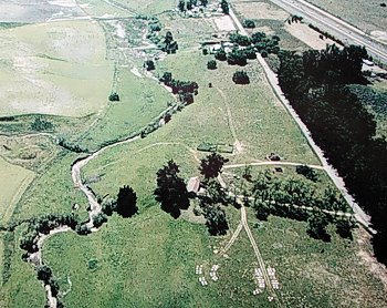
A fly-over view of the Dana Adobe with surrounding land, including the Nipomo Creek.

The Dana Adobe, which stands at the edge of the Nipomo Mesa overlooking the Nipomo Valley, has a commanding view of the Nipomo Valley. Captain William Goodwin Dana managed his expansive 38,000 acre rancho from here. This rancho, granted to him by the Mexican government, stretched from the top of the Temetatte Ridge in the east to the dunes in the west, from Los Berros Creek in the north to the Santa Maria River in the south.

In 1837, when construction on the Dana Adobe began, Nipomo was part of a wild frontier still dominated by grizzly bears and oak trees. Numerous Chumash villages dotted the land around Nipomo, lending their names to places such as the Temetatte Ridge and Nipomo proper.

The Chumash legacy is physically evident throughout the area in the form of depressions in rocks near the foothills, once used for grinding acorns, and the Dana Adobe itself, which was constructed largely with Native American labor.

The view from the back porch of the Adobe (which originally was the front porch, facing El Camino Real) is just about the same view that Captain Dana and his contemporaries enjoyed. It takes little imagination to remove the few vestiges of modern society which have crept into the landscape—the cars jolting down Thompson Avenue, fences, power lines, and a handful of houses.

Taking a walk through the Adobe grounds offers a glimpse into the natural history of the place. The Captain's tree, a majestic old sycamore to the north of the Adobe planted by Captain Dana, seems to embrace the structure with its open branches. Numerous of bees busily dart in and out of a natural beehive in its great trunk.

Downslope from the Adobe, willow trees line the creekside. A clay mine at the bank of the creek supplied the material for the adobe bricks. During the part of the year when the mustard plants are in bloom a line of yellow flowers emerges in the fields adjacent to the creek, marking the general path of El Camino Real. Travelers upon this ancient roadway used to to discard of their seeds as they went.

The Adobe was an important place—one of four stopover points on the original mail route from Monterey to Los Angeles, a place where Captain John C. Fremont rested his troops, where policies of the early California government were discussed. A center of great cultural diversity, the Adobe brought together Native Chumash, Mexican and American peoples.

The Adobe is also unique in that it survives today with its viewshed relatively intact and the acres around it untouched by development. The potential for the future of the Adobe as a historic park is limitless, and this is precisely the point that Kandel made to the board of the California Cultural and Historical Endowment (CCHE) when we traveled to Sacramento.

It was an honor (and quite an interesting experience) for me to travel to the state capitol to help represent our little hometown. The Dana Adobe was one of over fifty projects seeking a share of $43 million in state funding. That the Adobe received funding—$861,000 of it—from this state-wide board is a testament not only to the hard work volunteers at the Adobe, but also to its historical significance to the state of California.

The Dana Adobe is a resource for the entire community. There are countless tales to be told about the people who lived here: of how they interacted with the Natives, of how they conducted business, of how the helped to lay the foundation for the future of all Californians.

So this next weekend plan a visit to the Dana Adobe. Chances are you'll learn something you didn't know about Nipomo's rich history.

Wednesday, August 15, 2007

Natural Nipomo: The Nipomo Mesa

On a recent Sunday morning I decided to take a bicycle tour of the Nipomo Mesa.

The Nipomo Mesa is a massive sand dune, stretching from the shore side dunes in the west to the Nipomo Creek in the east, from Los Berros Creek in the north to the Santa Maria River Valley in the south. At some points the sand is 300 feet thick with alluvial deposits and layers of clay interspersed.

I set off towards the Mesa's edge, heading towards Guadalupe. After a quick descent I was at the base, looking up at the massive sand formation towering more than one hundred feet above me.

The Santa Maria River once flowed along the southern border of the Nipomo Mesa, carving the impressive bluffs on the south face. Riding along the base of the Mesa I could see the the eucalyptus trees emerging from the grassy sides of the mesa. At the top houses skirted the edge, practically sticking their tongues out at the forces that shaped the Mesa.

I rode back up the Mesa, and then on to the high bluffs where I could catch the view. After climbing to the top I stopped. The Santa Maria Valley stretched on before me all the way to the Point Sal Range. To my left the city of Santa Maria sprawled into the distance. Beyond that I could see the imposing peaks of the mountains of the Los Padres National Forest. To my right was the ocean, shrouded this day by a low-lying fog. The dunes followed the line of the shore, marking the end of the earth which man can tame.

When I visit a place I often wonder what it used to look like, before it was graded for construction or sewn for the harvest. Humans have had a profound impact on the environment, but without knowing what the land to look like it can be hard to visualize.

At the Nipomo Native Garden it takes little imagination to see what the Mesa used to look like. Volunteers have worked on this park at the intersection of Osage and Camino Caballo for years, planting native plants, building benches and clearing trails. Now the park features restored natural habitat representing many of the communities which once dominated the Nipomo Mesa: coastal sage scrub, manzanita, oak woodland, chaparral, grassland and wetland. Visit the Nipomo Native Garden website, aptly located at www.nipomonativegarden.org, for information on native plant species that grow there.

I took a stop in the garden, sitting down to read some of the literature that is often left in boxes there. While engrossed in a piece of Native American poetry discussing the life cycle of oak trees, I heard a familiar barking and yelping approaching me.

Bill Deneen was there, along with his two very vocal dogs. I got to talking with him about what Nipomo used to look like. “When I moved here in 1962,” Deneen told me, “what you see [in the Native Garden] was all over the place. I couldn't figure out why they had a park in the middle of nowhere,” he continued, referring to the Regional Park which was once surrounded by undeveloped land. “What you see here was all over there,” indicating one recent development, “and all over there,” indicating another.

After Deneen left I walked my bike to the back part of the gardens, where a trail with more of those hand-painted “Don't Litter” signs runs through and old growth oak woodland. This is a fun little trail—I could hear the cars zipping by on Pomeroy, unaware of the special little place they were passing in such a hurry.

Here there is a particular oak tree, gloriously ancient, which has been dedicated to Bill Deneen. A plaque at its base proclaims the dedication, with an additional quote from Henry Thoreau: “I went into the woods because I wished to live deliberately.”

Birds chirped all around me, the midday sun shone brokenly upon my face, the sounds of the cars faded as I succumbed to nature's embrace. I knew this is how Nipomo should be. This is how it was.

Thursday, July 26, 2007

Natural Nipomo: The Dune Lakes

Black Lake is one of a myriad of dune lakes that lie between the Nipomo Mesa and the Oceano Dunes. These lakes are unlike anything else in the county, a rich ecotone habitat which supports many unique bird and plant communities.

I was fortunate to have the opportunity to spend a recent summer night camping in the dunes. We set out by car in the evening and pulled over onto a dusty side road off Highway 1, easily missed by those just passing by. We parked next to a rusty old Ford truck, evidently a long-time neighbor of the dune lakes, and unloaded our gear.

Legendary dune photographer David Stroup joined us on the hike. Stroup has been visiting the dunes for decades, and handily carried his photography equipment down the mile-or-so-long dirt path to the lake.

The path meanders its way through a stand of Eucalyptus trees. In January and February monarch butterflies come in droves to live in these trees, and it is around this time that the Land Conservancy holds its annual hike to Black Lake.

Through the trees I caught shimmering glimpses of the the lake. I was eager to see it in full—it had been a while since I'd visited my favorite place in Nipomo. The trail worked its way into the dunes. We walked up onto the ridge which runs along the south of the lake, and there it was.

Black Lake lies west of the mouth of Black Lake Canyon. It is likely that the same flood waters that carved out the canyon also formed the lake. One theory propounds that clay lenses and organic matter underneath the ground may help seal the lake bottom. Intrusion of the sand dunes captured the waters which once flowed unimpeded to the ocean, and a lake was born.

"There's a whole lot we don't know about this lake," says Herb Kandel, a Land Conservancy board trustee who arranged our special access and accompanied us on the trip. He would like to see more scientific study conducted in Black Lake.

The Land Conservancy owns the 160 acre parcel on which Black Lake sits. The rest of the dune lakes to the north are owned by Dune Lakes, Limited, a private hunting club. The Land Conservancy holds a conservation easement over these lakes, ensuring that they too will be protected.

As we walked along the ridge we saw a deer scramble into the dunes. We made our way to the top of a dune from where we could see the lake beneath us and the rest of the dunescape all around, the deer's tracks disappearing into the distance. Stroup noted that the dunes are always moving, likening their motion to the waves of the ocean.

The area around Black Lake, like many other sites in the dunes, was once inhabited by the indigenous Chumash people. Close to our campsite we stumbled (quite literally) across an old shell midden. We also found a gorgeous obsidian flake in the vicinity, likely a high quality trade item from a prize quarry. It is stunning to think that today we can gaze upon the same lake the Native Americans did under relatively similar conditions, away from most of the noise and bustle of modern life.

Towards twilight an Amtrak train rolled by on the tracks that run adjacent to Highway 1, easily visible from our campsite. Trains continued to roll by through the night and into the morning.

Nighttime is always spectacular in the dunes, but especially so at Black Lake. Though it wasn't too cold we gathered around a campfire. Drums were drummed, stories were storied. We talked about the old west, about our lives and concerns, about the lake and all the other special places around Nipomo. Black Lake has a way of bringing about a reflective mood in those who visit it.

We went to sleep that night in a wilderness, as one of my friends put it, in our own backyard.

I awoke to the improvised sounds of a Japanese Shakuhachi flute played by Kandel, and to the melodious chirping of birds all around me. There was also the roar from the engines of some early-rising ATV riders. How can they hear the chirping of the birds over the roar of their engines, I wondered.

After breakfast we descended to the lakeside, scrambling down the scrub (and poison oak) covered dune face. The wildflowers were blooming. Here a fish jumped out of the water. There a bird dived under.

Walking along the muddy bank we made a particularly notable discovery—a robust specimen of yellow pond lily (Nuphar luteum). This lily is a spectacular plant, certainly one of the most interesting I've ever encountered. It's broad leaves could cover your face, and all its shoots come from a pineapple-like rhizome, which stores energy for the plant. I will not attempt to describe the beauty of its yellow flower

After a few hours of exploring it was time to go. We donned our gear (significantly lighter now that we had drunk much of the water) and set out once more on the trail around the lake, sampling wild gooseberries along the way. I turned around and took one last look at the lake, bidding it a silent goodbye.

As I prepare to head off for UC Davis in the fall I wonder what will become of all the natural areas around Nipomo. Development in the middle of town is increasing. New houses continually pop up, and roads are being built or realigned to support our fledgling community.

Black Lake holds a special place in my heart. Fortunately, access to Black Lake is strictly limited—just ask the watchman who vigilantly guards the lakes, if you dare. Though I encourage everyone who has a chance to visit the lake to do so, I rest easier at night knowing that the lake will still be there in all its splendor when I am old.

Monday, July 2, 2007

Natural Nipomo: The Dunes

The dunes have an undeniable mystique. Tufts of sweet-smelling plants poke out of the sand, the winds whistle, seagulls soar overhead, and snowy plovers dart to the shore. Every now and then you'll be sprayed with the sea mist from a crashing wave. Every time I go there I discover something new.

The dunes run from Oceano in the north to Mussel Point in the south. A few weeks ago my family took a hike with Nipomo's resident environmental sage Bill Denneen. We parked behind the Oceano airport and Bill led us down a path running along the levy, parallel to the Arroyo Grande Creek. We crossed the creek and went into the dunes, munching on wild blackberries along the way.

Bill shared a little of his vast knowledge with us, gathering wildflowers to show us and telling stories of the old days. He pointed out large piles of discarded clamshells called shell middens, evidence of the ancient inhabitants of the dunes.

The process by which dunes are formed is truly all-encompassing. Creeks carry sediment from inland areas and deposit it into the ocean. This sediment then gets washed ashore by the waves. The winds take over next, blowing the fine sands inland and shaping the dunescape into rolling masses of sand.

The Dune Center in Guadalupe is a good resource for those making trips into the dunes. I stopped there on another trip into the dunes. Bill had mentioned Mussel Rock during his hike, a place where the rocks jut out into the sea. Finding myself curious and in need of adventure, I called up some friends and we set off.

--

From the early twentieth century to the 1970s people lived in the dunes. They slept in tree-covered coves in the dunes, in cottages they built from driftwood. They were poets, hermits and philosophers, living off the bounty of the ocean. Some sought solitude, others enlightenment and lively intellectual discussion. Among the Dunites (as they were called) were many luminaries, including Gavin Arthur, the grandson of President Chester Arthur. Norm Hammond's wrote a fascinating book about these dune inhabitants called The Dunites. I strongly recommend it.

One of the more popular dune sites to visit is Oso Flaco Lake, so named by Spanish explorers who saw a rather undernourished bear in the vicinity. Here a boardwalk crosses the lake, affording close views of the aquatic birds who dip and dive under the water. The boardwalk continues through the lush dune habitat all the way to the beach.

--

Our trek to Mussel Rock began from the parking lot in the Guadalupe-Nipomo Dunes Preserve, at the end of West Main Street. We walked through areas that have appeared in numerous Hollywood films, from the great Egyptian city in the 1923 epic The Ten Commandments to Davy Jones' locker in Pirates of the Caribbean.

We stopped after a few miles when the beach began to narrow. I broke off from the group and climbed a dune by myself. I wanted to get a closer look at Mussel Rock before we headed back. One of my friends climbed a similar dune north of where I was, while the rest constructed a seaside house from driftwood and other articles.

The sun shone happily down upon the high dunes as I climbed. Here I was far enough away from the vehicle area to get some peace and solitude, without the roar ATVs. I gazed at Mussel Rock to the south and beyond that to Point Sal. To the north I could see the Santa Maria River delta and the dunes beyond. The blue ocean extended forever to the west. Colorful wildflowers covered some of the dunes.

I descended back down to the beach and we trudged back through the sand, but not before noticing the paved remnants of what appears to be a forgotten highway through the dunes. What were they thinking when they built this road? Most of it is now covered in sand.

The dunes are a natural wonder given to all of us to enjoy and protect. Whether it's your first time in the dunes or you've been there many times before, you're certain to find something new on your next visit.

Tuesday, June 26, 2007

Natural Nipomo: The Nipomo Creek (and Valley)

On a recent summer morning I decided with a couple of friends to visit the Nipomo Creekside Preserve. We rode our bikes down Tefft Street and turned into the Adobe Plaza. We rolled on behind the shopping center and came to a stop at the entrance to a gravelly path.

The Nipomo Creekside Preserve was established a few years back by the Land Conservancy. Its 2.5 acres have been set aside for preservation and planted with native plants. Local volunteers and student organizations at Nipomo High School work in the preserve to remove invasive species and conduct new plantings.

The Nipomo Creek flows through the Nipomo Valley, making up the eastern border of the Nipomo Mesa. The Nipomo Valley is a lush region defined by its hills. Its historical significance is noteworthy: it has been home to Native Americans and Captain Dana's cattle, it has hosted John Fremont's army of conquest and the family of pea picker's immortalized by Dorothea Lange.

To the west of the creek are stabilized sand dunes. To the east the soil consists of largely adobe clay. The Nipomo Creek is fed by numerous smaller creeks that flow down from the foothills of the Temetatte Ridge during the rainy season.

As we explored the park we saw hand-made signs (painted on the backs of old political advertisements) declaring, “Trail, do not litter.” I had been to the preserve many times before, but I had never seen any trail before. We decided to follow the signs.

Adjacent to the Creekside Preserve is the proposed Jim O'Miller Memorial Park. Notable here is the white railroad crossing sign. A plaque at the foot of this sign describes the history of rail in Nipomo. The line once ran from Avila to San Luis Obispo, through the Edna Valley to Arroyo Grande and Nipomo, and on south to Los Olivos. “This railroad served as a major influence in the development agriculture and commerce on California's central coast from 1886 to 1942,” the plaque reads.

The trail wrapped around the edge of the park, along the fence line. When it reached the banks of the creek, there were some cut-out steps. We descended.

No water was flowing through the creek for this summertime visit. I have been to the creek in the winter, though, when water flows plentifully. In big storms the creek swells to depths of ten feet or more. Evidence of this can be seen in the bits of dead organic material left hanging in willow trees, caught up in the branches during the last torrent.

We looked around. A discarded tire lay half-buried in the bank in front of us. There were a few empty food wrappers. The volunteers do a good job of cleaning the creek, especially before the rains, but it is still a shame to see the rocky creek bed littered.

My friends and I followed the signs down the creek bed. The sun poured through gaps in the leaves above. Insects flew around us, birds chirped. We saw a few lizards.

After a while we reached the convergence where the Haystack Creek meets the Nipomo Creek. Around us were willow trees and oaks, licorice plant and other riparian plants. Near here the trail goes up the bank again, where there are elderberry, coyote brush, lilacs, a stand of eucalyptus trees looking quite out of place, and an oak grove which would look inviting but for the poison oak.

“You don't see these plants anywhere around Nipomo anymore,” says Ian Wells, a recent graduate of Nipomo High School and an amateur naturalist, referring to the California lilac.

Closer to the Tefft Street bridge were poison hemlock and soap plant. Poison hemlock is a tall slender plant with clusters of small white flowers. The poison from this plant was used to execute the Greek philosopher Socrates. Soap plant—a member of the lily family—was used by the Native Americans, who consumed parts of the plant and also used its bulb for soap.

There are plenty of other places to see creek. The Dana Adobe's annual heritage day is a great opportunity—my friends and I have personally led creek hikes there the last couple of years. At points south of the Dana Adobe the creek widens into wetlands, which serve as resting places for migratory birds. Some of these sites can be seen from Thompson Road and from the freeway.

Corrine Ardoin's definitive book, A Natural History of the Nipomo Mesa Region, offers a point-by-point tour of Nipomo in addition to its lyrically detailed descriptions of the land and its history. I strongly recommend it. The roadside tour will take you to many sites of interest in the Nipomo Valley, from rock formations off Dana Foothill Road once used by the Chumash to fault lines running at the base of the Temetatte Ridge.

Though sometimes tempestuous, the Nipomo Creek offers a natural getaway in the heart of Old Town Nipomo and a glance into Nipomo's rich past. Go there after a light rain, bring along a book or a friend, and sit and enjoy nature's local fountain for yourself.

Tuesday, June 19, 2007

Natural Nipomo: Black Lake Canyon

Natural Nipomo was a column published in the Adobe Press, the newspaper for the Nipomo community, in the summers of 2007 and 2008. Twice a month I discussed a different natural area of Nipomo, focusing on geological and biological features and the cultural significance, with my own personal impressions added. This was my first Natural Nipomo article.

As we descended into the canyon I could hear the chirping and kawing of birds and the creaking sounds of the eucalyptus trees. It was senior week, my last week as a student at Nipomo High School, and I tagged along on a field trip through Black Lake Canyon.

I'm a member of the high school's most recent graduating class. I plan to study biology at UC Davis in the fall. My years at NHS taught me many things, among them the importance of protecting the natural environment.

This isn't something I learned in the classroom. I learned by seeing firsthand the special places that surround us in Nipomo. Having seen where it's gone wrong, I think its important to visit the places where we still have a chance to do things right.

Members of Nipomo High School's Progressive Club take a hike through the disturbed habitat of Black Lake Canyon.

The hike moved on. Rays of sunlight broke through the oak trees overhead, gracing the leaves of ferns and shrubbery below. A thick grove of willow trees emerged from the wetlands. When I last visited the canyon about a year ago there was more open water and there were fewer willows. Black Lake Canyon is an example of an ecosystem undergoing succession, wherein habitat gradually changes and new species take the place of old. This is a natural process, but in the canyon it is greatly accelerated.

Black Lake Canyon was formed thousands of years ago at the end of the last ice age. Local experts postulate that it was carved out by a catastrophic flood that came from wetlands near present-day Nipomo High School. These floodwaters broke through the blowsand of the
Nipomo Mesa and made their way to the ocean. What remains today are four miles of canyon and the dune lakes system.

Two endangered species inhabit Black Lake Canyon. The first is the marsh sandwort (Arenaria paludicola), a perennial plant with a tender white flower. The other, Gambel's watercress (Rorippa gambellii), is a member of the mustard family. Gambel's watercress needs a stable water source to survive. Both species are threatened by development around the canyon, which causes erosion and habitat loss.

Thanks to the efforts of Ray Belnap, a former director of the Land Conservancy, the canyon has been designated a sensitive resource area. One provision of this designation designed to protect sensitive habitat within the canyon forbids the construction of homes below the rim of the canyon.

Our hiking group crossed Zenon Way and entered Land Conservancy property. A quick stroll through a stand of Eucalyptus trees brought us to a massive gully created by washout. Sheer walls of sand lined by fallen tree trunks rose twenty twenty feet. Naked roots hung over the sides.

"This is an ecological disaster due to the runoff from a neighboring property," says Herb Kandel, a board member of the Land Conservancy who led the hike that day. Greenheart Nursery has a retention pond at the top of ridge of the canyon. In flood years the pond overflows, sending a torrent of water into the canyon which carries sediment into the marshland habitat below.

Illegal dumping is another problem in the canyon. Big screen televisions, couches, computers and countless other items have been removed from the canyon, and workers have removed hundreds of tires. The charred remnants of a burned trailer were found not far from a now-closed road which runs through the canyon. Had the fire from this trailer spread, it could have set the Eucalyptus trees ablaze.

Erica Castello, now a senior at Nipomo High School, was a first-time visitor to the canyon when she came along on the hike. "It gives you a glimpse into what Nipomo should really look like," she says. "It gives you a look into how much we've already damaged our natural environment."

But there is much more to see than just the tragedy of the commons. Black Lake Canyon has some of the most pristinely untouched habitat left in Nipomo. You can visit the canyon at the north end of Guadalupe Road or the southernmost end of Zenon Way. From here you
can access trails that meander through oak woodlands and chaparral grassland. At the corner of Highway 1 and Callendar Road is a new park owned by the Land Conservancy which has sweeping views overlooking the canyon. Go to the canyon and see for yourself what Nipomo should look like.